When videos of houses falling into the ocean in North Carolina’s Outer Banks appeared on the news, it shocked everyone. The scenes showed homes breaking apart and sliding into the surf after days of strong waves and king tides. For people living near Wilmington—especially in Wrightsville Beach, Carolina Beach, and Kure Beach—it raised a serious question: if the ocean can move that fast, is your flood elevation certificate still right?
A flood elevation certificate is a report that shows how high your home sits compared to the area’s expected flood level. It’s what helps insurance companies, lenders, and cities know your real flood risk. But if storms change the land around your home—even a little—your old elevation data may no longer be correct.
The Coastline Is Always Changing
The North Carolina coast never stands still. Every tide, storm, and beach project moves the sand a little bit. The line where the ocean meets the land, called the high-water line, can shift every season. When dunes erode or sand is pumped back onto the beach, the ground level changes too.
Ocean Isle Beach, just south of Wilmington, is already planning another round of beach renourishment after king tides washed away parts of its shoreline. The goal is to rebuild dunes and protect homes, but when that happens, nearby property elevations change.
Even a small change in elevation—sometimes just a few inches—can move your home into a new flood zone. That means your flood insurance rates, or even your ability to get coverage, could change. Old certificates might not match the new ground height, leaving homeowners with outdated information when they need it most.
Why It’s More Than a Paper Problem
Many people think a flood elevation certificate is something you only need once. But in coastal towns like Wilmington, the land shifts too often for that to be true. If your certificate was made before a big storm or a beach repair project, the numbers may no longer match what’s really on the ground.
For example, when dunes in front of a house wash away, the lowest part of the yard drops closer to sea level. That small drop can increase your flood risk and raise your insurance rates. FEMA and your insurer use those numbers to decide how much risk you face. If your certificate is outdated, they may be looking at the wrong data.
And that’s not just about money—it’s about safety. When flood zones change and the ground around homes lowers, water can reach higher than expected during a storm. A current flood elevation certificate gives a clear picture of how safe your home really is.
How Surveyors Measure the Difference

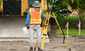
After a major storm or erosion event, surveyors play a big role in getting new data. Their job isn’t only to mark property lines. They also measure the ground around your home to see how the landscape has shifted.
Using GPS tools and high-accuracy instruments, surveyors check your finished floor elevation (the height of your home’s main floor) and your lowest adjacent grade (the ground next to your foundation). These numbers go into a new flood elevation certificate.
Surveyors also check that their reference points, called benchmarks, are still correct. These benchmarks are part of a national elevation system known as NAVD88. If erosion or flooding has disturbed the area, those points might have moved slightly and need to be rechecked.
In beach areas like Wilmington, surveyors look at the dune crest, the slope leading to the water, and any seawalls or decks nearby. They use this data to understand how the beach or yard has changed and how that affects flood risk.
How the Outer Banks Story Connects to Wilmington
The collapsed homes in the Outer Banks were a dramatic reminder that the coast is always in motion. The same ocean forces that caused damage there also shape the beaches of Brunswick and New Hanover Counties.
Ocean Isle Beach and Holden Beach, for example, are already adjusting their sand replacement schedules to keep up with erosion. These projects can protect property, but they also change the shape of the shoreline and the base elevation that flood maps use. When those numbers shift, homeowners need updated certificates so everyone—from insurance agents to city planners—works from the right data.
If your property is near the water, you’re part of this same system. The coast changes a little every year. You may not notice it from your porch, but surveyors can see it clearly in the numbers.
When to Update Your Flood Elevation Certificate
You don’t have to wait for disaster to strike before checking your data. Here are times when updating your certificate makes sense:
- After erosion or dune loss: If waves have cut into the beach or your yard, the ground may be lower than before.
- After beach renourishment: When sand is added back to the shoreline, the local floodplain may change.
- After your flood insurance changes: If your premium suddenly jumps or your agent asks for a new form, it may be because the old one is out of date.
- After home improvements: Even adding stairs or rebuilding a deck can change your measured elevation.
- After new FEMA maps are released: These updates can move homes into higher or lower risk zones.
Catching changes early keeps you ready for storms and helps avoid problems when selling, refinancing, or renewing insurance.
Wilmington’s Moving Landscape
Wilmington’s coastline never stays the same for long. Dunes are repaired, canals fill and drain, and new sand moves in with every project. Wrightsville Beach and Carolina Beach rely on regular sand pumping to hold the line against erosion. Those changes slowly reshape the ground that homes sit on.
Homeowners often notice small signs first—yards that stay soggy longer, driveways that collect puddles, or flood water reaching further during heavy rain. These are hints that the local elevation might have changed.
Surveyors track those differences after each storm season. Their updated data feeds into FEMA’s flood maps, which help the whole community plan for future flooding. By keeping your certificate current, you’re helping not only yourself but also your neighbors who rely on those maps for accurate risk information.
Stay Ahead of the Next Headline
The scenes from the Outer Banks were heartbreaking, but they’re also a warning. Flooding risk doesn’t only come from hurricanes—it changes with every tide, storm, and shoreline project.
Checking your flood elevation certificate now can save you stress later. A quick update ensures your records match the real ground level of your home. That can make a big difference in insurance costs and in understanding how safe your property really is.
If you live in Wilmington or nearby beaches, reach out to a licensed land surveyor who knows local flood zones. They can recheck your property and prepare a new flood elevation certificate that reflects your current conditions.
The coastline will keep changing. Your home’s protection shouldn’t fall behind. By staying proactive, you keep your peace of mind—and your property—above the tide.


