If you’re buying or selling property near the coast right now, there’s one document that could make or break your deal — the elevation certificate. In the middle of new storm damage, shifting dunes, and FEMA’s budget delays, this simple survey report has suddenly become one of the most important pieces of paper in local real estate. And if you don’t have a current one, your closing could stall fast.
The Storms Aren’t the Only Problem
Over the past few weeks, Wilmington has been hit from two sides. On one hand, our coast took another beating from early October’s nor’easter, followed by more rough surf that eroded dunes along Wrightsville Beach and Carolina Beach. The U.S. Army Corps of Engineers is now reviewing the area to decide when beach renourishment will begin — but those projects could take months.
At the same time, the national flood insurance system is under financial pressure. When that happens, insurance approvals start to slow down, especially for properties near water. In flood-prone areas like Wilmington, even a short delay in insurance processing can affect property closings.
When FEMA funding stalls, the NFIP slows down. And when the NFIP slows down, flood insurance approvals start backing up. The first victims are real estate closings — especially for homes near water. Without an updated elevation certificate, lenders and insurers won’t risk moving forward.
Why the Elevation Certificate Is Suddenly Urgent

Normally, an elevation certificate is something homeowners order once — usually when they buy, build, or refinance a house in a flood zone. It shows how high the property sits compared to the expected flood level, called the Base Flood Elevation. Lenders and insurance companies use this document to decide if the home meets flood safety standards.
But here’s the issue: Wilmington’s land isn’t staying still. Every storm shifts the sand and changes the contour of our coastline, even by just a few inches. When that happens, the old data on an elevation certificate might no longer match the real ground level.
That small difference matters. It can move a property into a higher-risk flood zone, which then changes insurance rates — and that, in turn, affects your lender’s approval. With FEMA already reviewing disaster claims and floodplain data, expect tighter checks and stricter documentation in the weeks ahead.
How Closings Get Caught in the Middle
Imagine you’re days away from closing on a house near Bradley Creek or Masonboro Sound. The lender’s underwriter spots that the property’s flood zone data was updated after the last storm. Suddenly, they ask for a current elevation certificate before releasing funds.
Now you’re waiting three to five more days for a surveyor to visit the site, collect data, and file the new report. Your closing gets pushed. The seller has to reschedule movers. Insurance quotes change. What started as a smooth transaction turns into a scramble.
These kinds of delays are happening across coastal North Carolina right now. Some lenders are even holding closings until FEMA’s funding outlook becomes clearer. The risk is simple: if your property’s elevation data isn’t up to date, your deal could be next on hold.
Wilmington’s Shifting Ground Keeps Everyone Guessing
What makes Wilmington tricky is that our floodplain maps are living documents. Between local rain patterns, coastal erosion, and renourishment projects, the landscape keeps evolving. A dune that existed last year might be gone today. A low yard might be even lower now.
Local surveyors have already noticed changes along Wrightsville Beach, Carolina Beach, and the Cape Fear River corridor. Those subtle drops in ground elevation can move properties closer to flood thresholds — especially where FEMA’s Base Flood Elevation line is already tight.
Even if your home hasn’t flooded before, the new topography could place it in a different flood zone. And because insurers and lenders follow FEMA’s data, the only way to confirm your property’s safety is through a verified elevation certificate prepared by a licensed surveyor.
Acting Before the Delays Start
You don’t have to wait for your lender to demand it. Ordering a fresh elevation certificate now is the most proactive step you can take. It shows that your property’s elevation matches the latest ground conditions and gives you control over your timeline instead of waiting for someone else to flag an issue.
Start by checking your property’s status on the Flood Risk Information System (FRIS). This free online tool lets you search your address and view current flood maps. If your property falls within or near a Special Flood Hazard Area, that’s your cue to get in touch with a local surveyor.
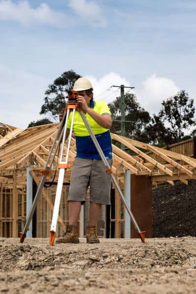
Once you order, the surveyor visits your property, measures the foundation and surrounding grade, and compares those points to the area’s Base Flood Elevation. You’ll get a certified report that you can share with your lender and insurance agent immediately.
In Wilmington, many surveyors can deliver this within a few business days, but schedules are filling up fast due to increased demand after the storms. Acting early can save you a week of stress — and potentially thousands of dollars in rescheduling costs.
The Real Cost of Waiting
Some homeowners hesitate to spend the few hundred dollars it takes to get a new certificate. But compared to the cost of a delayed or canceled closing, it’s a small price to pay.
When flood insurance can’t be finalized, everything stops — no loan, no transfer, no coverage. And if your closing falls into that gap during FEMA’s budget freeze, you might have to restart paperwork or lose your locked interest rate.
An updated elevation certificate can also help you lower your flood insurance premium if it proves your home sits higher than expected. Several homeowners have seen significant savings this way after post-storm surveys revealed better elevations than the old maps showed.
What This Means for Buyers and Sellers
This moment is more than just another bureaucratic hiccup. It’s a reminder that in a coastal market like Wilmington’s, data and timing can make or break your deal. Between federal funding uncertainty and local erosion changes, real estate transactions need to move with precision.
For buyers, that means confirming elevation data early in the process — not days before closing. For sellers, it means keeping your documentation current to avoid losing a buyer over an unexpected delay. And for realtors or lenders, it’s about helping clients stay ahead of red tape by encouraging them to verify elevation details right now.
Final Thoughts:
Every real estate market has its challenges, but Wilmington’s are unique. Our shoreline shifts, FEMA’s programs adjust, and policies change fast. Yet one thing remains constant — accurate elevation data keeps deals moving.
Before you get swept up in the next policy update or storm season, make sure your elevation certificate is up to date. A short call to a licensed land surveyor can keep your sale or purchase on track, protect your investment, and give you peace of mind long after the waves calm down.


